




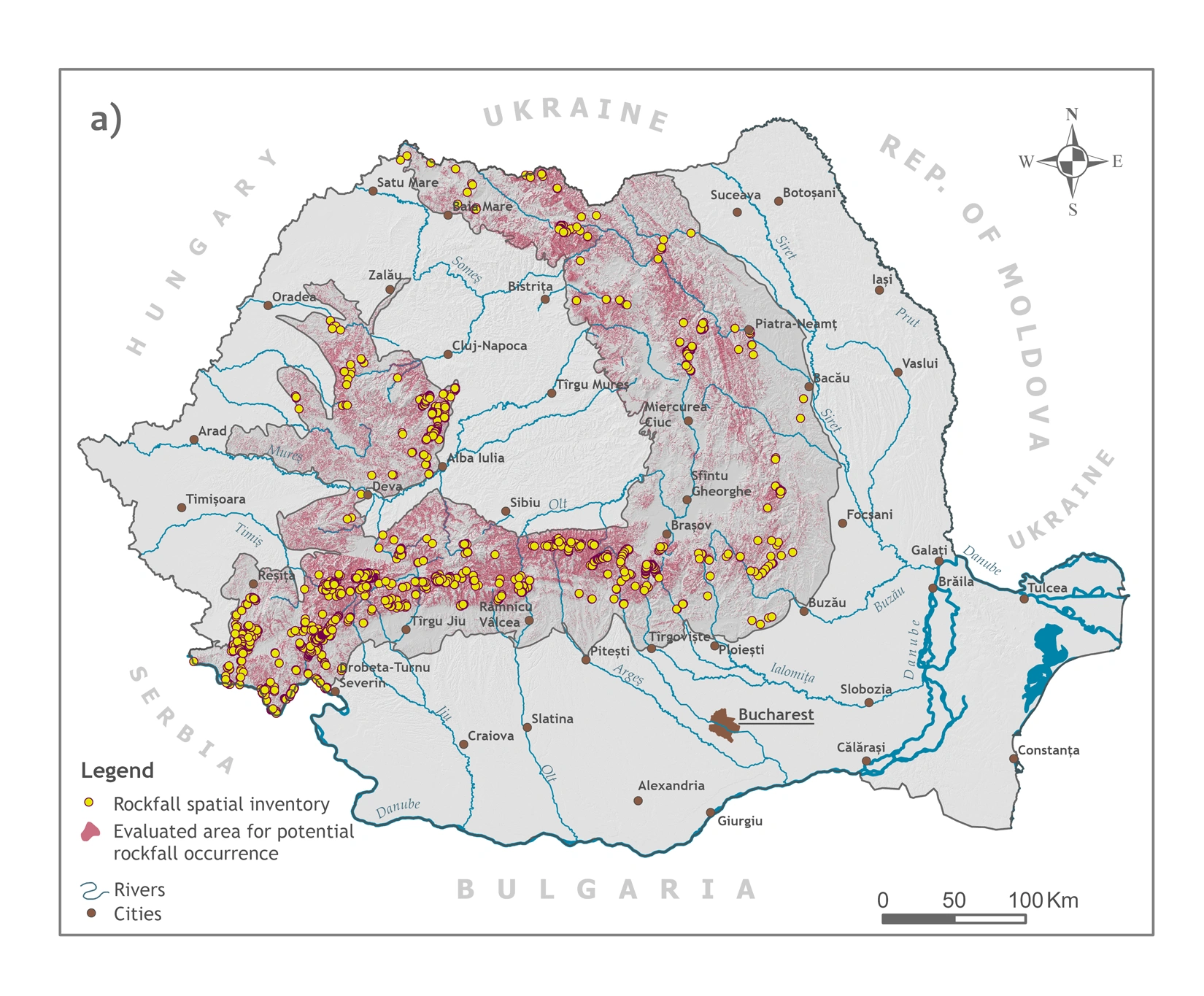
Research led by the University of Bucharest (UB) has produced Romania’s first national map of potential rockfall occurrence, identifying areas across the country that are susceptible to rockfalls. Researchers from the University of Bucharest, the Alexandru Ioan Cuza University of Iași (UAIC) and the Romanian Academy’s Institute of Geography identified approximately 1,500 km² of land with a high potential for rockfall occurrence, 97% of it located in the Carpathian Mountains. The study, “Spatial modelling of potential rockfall occurrence in Romania using the Weight of Evidence method,” was published on 18 June 2026 in Scientific Reports, a peer-reviewed journal in the Nature Portfolio.
“Until now, Romania lacked a nationwide tool capable of identifying areas susceptible to rockfalls. To develop this map, we compiled an inventory of 1,743 rockfall source areas, identified through scientific literature, geological maps and field observations. The resulting map can support feasibility studies for mountain infrastructure projects and help prioritise investments in slopes adjacent to roads and railways. Authorities responsible for natural hazard management, from the National Road Infrastructure Administration Company and the National Railway Company to regional development agencies and local authorities in mountain areas, can use these data to inform spatial planning and risk reduction strategies”, explained Dr Adriana-Bianca Ovreiu, researcher at the University of Bucharest’s Faculty of Geography and lead author of the study.
Using the inventory of 1,743 documented rockfall source areas, the research team analysed 19 geological, geomorphological, climatic, ecological and geospatial variables, including slope gradient, bedrock type, vegetation cover, seismicity, daily and seasonal temperature ranges that reflect freeze-thaw cycles capable of fracturing rock, snow accumulation, and proximity to rivers and roads. The researchers applied the Weight of Evidence (WoE) statistical method to estimate the likelihood of rockfall occurrence based on the observed relationship between previous rockfall locations and each environmental factor. Validation showed that the best-performing model achieved an overall classification accuracy of 94%, and the resulting national map highlights the areas most susceptible to rockfalls in shades of red. Among the factors most strongly associated with potential rockfall occurrence were slope gradient and vegetation cover. In areas where forest cover exceeds 87%, the probability of rockfall occurrence falls to just 2.2%, highlighting the important protective role of dense vegetation.
Rockfalls are a distinct type of geomorphological hazard. Unlike many landslides, which often move slowly over months or even years and may allow time for mitigation measures, rockfalls occur suddenly and leave virtually no time for response. A rock mass detaches abruptly from a steep cliff or rock face, accelerates downslope under gravity, and may travel several hundred metres before coming to rest.
“Rockfalls are the only type of landslide process that has caused fatalities in Romania because of the speed and energy they develop. Even relatively small rocks can become highly destructive because of the kinetic energy they accumulate as they fall. Many of Romania’s most spectacular tourist destinations, including gorges, cliffs and narrow valleys with steep rock walls, are also among the areas most exposed to rockfall hazards,” explained Associate Professor Mihai Niculiță of the Faculty of Geography and Geology at Alexandru Ioan Cuza University of Iași, co-author of the study.
The researchers emphasise that the model identifies potential rockfall source areas rather than predicting how individual rocks will travel downslope or where they will ultimately come to rest.
“Trees generally stabilise slopes, although at a local scale their roots can sometimes widen existing fractures in rock. Overall, however, dense vegetation remains one of the strongest protective factors. At the same time, roads, railways and other infrastructure crossing the Carpathians may destabilise slopes through excavation and construction. These areas require continuous monitoring, and we now have a tool that identifies where such monitoring should be prioritised,” added Associate Professor Mihai Niculiță.
The research was led by Dr Adriana-Bianca Ovreiu of the University of Bucharest’s Faculty of Geography and funded through Romania’s National Recovery and Resilience Plan (PNRR) as part of the project “Complex modelling of multiple land degradation processes in Europe: Towards an integrative scientific framework for sustainable land management across the continent,” coordinated by Associate Professor Remus Prăvălie of the University of Bucharest’s Faculty of Geography. Within the research team, Associate Professor Mihai Niculiță (Faculty of Geography and Geology, Alexandru Ioan Cuza University of Iași) contributed to the study’s methodological framework and the interpretation of the factors controlling rockfall occurrence, while Dr Nicușor Necula (Faculty of Geography and Geology, Alexandru Ioan Cuza University of Iași) was responsible for integrating high-resolution remote sensing and spatial analysis data.
Postări asemănătoare:
 On Saturday, 24 January 2026, the University of Bucharest marked the start of a scientific expedition to Antarctica, involving four researchers from the University of Bucharest and the National Institute for Research and Development for Biological Sciences (INCDSB)
 The University of Bucharest announces the launch of the evaluation results for ICCS – International Civic and Citizenship Education Study, the largest and only dedicated study of civic and citizenship education
 The University of Bucharest announces the launch of ICCS 2022 results – International Civic and Citizenship Education Study, the largest and only dedicated study of civic and citizenship education
